
Patagonia
Cabo Froward and Dientes de Navarino
We arrived in Punta Arenas after 50 hours on a bus from Santiago. Flying within the country is cheap and obviously more convenient, but we try to avoid it for environmental reasons. Along the way we passed the Villarrica volcano and endless pampas, where we spotted guanacos, rheas, condors, and flamingos.
From Punta Arenas, we set off on a three-day trek toward Cabo Froward — the southernmost point of the American continent itself (excluding the islands) — where we became well acquainted with the famous Patagonian winds. The HMS Beagle also docked here, and Darwin hiked up Mount Tarn, encountering a strange mushroom and the Yaghan people. We didn’t climb Mount Tarn because recent heavy rains would have left us sinking in mud up to our hips, and we didn’t meet any Yaghans, as they are now extinct. We did, however, try the strange mushroom — now called Darwin’s fungus — and admired the beautiful Fuchsia magellanica surrounded by hummingbirds. Punta Arenas is also a great place for exploring old shipwrecks.
From Punta Arenas we then took a 30-hour boat trip through the Beagle Channel to Puerto Williams on Navarino Island in Tierra del Fuego. Waves, wind, fog, fjords, glaciers, seals, and even a whale created an unforgettable landscape.
After registering with the Carabineros, we immediately began the Dientes de Navarino circuit (with a detour to Lake Windhond), the southernmost trek in the world. Two dogs — which we named Darwin and Fitz Roy — followed us for five days, walking through muddy forests, rocks, snow, and bogs together, sleeping next to our tent at night, and happily hunting beavers.
On the opposite side from Navarino Island (the Chilean side) lies Ushuaia, on the Argentinian side — the southernmost city in the world and the so-called “gateway to Antarctica.” Despite the close proximity between Puerto Navarino and Ushuaia, only recently has a very limited and exorbitantly priced crossing service been established, allowing a maximum of 12 tourists per day. In this way, Argentina can curb the development of Puerto Williams. The conflict between Chile and Argentina over Antarctic territory is therefore still quietly ongoing, even after the 1978 war — itself the logical outcome of a century of southward expansionism on both sides. Chile, Argentina, and the UK all claim the Antarctic Peninsula and have established a presence there. Naturally, each country wants access to potential resources beneath Antarctica should exploitation ever become profitable, along with the enduring prestige of national claims.
Anyway, we ended up paying 100 euros each for a 20-minute ride to Ushuaia in a rubber boat. Unlike the charming village of Puerto Williams, Ushuaia felt like a place we had to escape quickly, mainly catering to elderly tourists with tax-free shopping and “exploration” cruises around the Antarctic archipelago.
Torres del Paine National Park
We spent eight days trekking in Torres del Paine, Patagonia’s most popular (and pricey) park. On the first day, together with a Romanian-Canadian guy, Denis, we climbed to the top of Mt. Paine. This required a special permit, as hiking is normally allowed only on official trails and camping or cooking only at designated campsites.
We walked along the ridge until strong winds forced us to stop and set up camp. Around 7 p.m. we found some shelter from the wind and secured our tent with large stones. By 9 p.m., however, the storm had reached our valley: incredibly strong winds combined with hail and snow coming from all directions. Denis’s tent collapsed on top of him. Daniel went out in his Tevas to secure our tent, but soon the stones anchoring the pegs were blown away and our tent started to come loose as well. Denis ran outside after his own tent, which had been lifted by the wind — he caught it and held it like a balloon in the air.
We quickly decided to descend back into the forest, an 800-metre drop in elevation. Daniel held our tent while I stayed inside, hurriedly packing mattresses, sleeping bags, and the rest of our gear. Visibility was extremely limited, as the tent was collapsed and flapping wildly while snow blew inside. Once packed, walking with heavy backpacks was still nearly impossible — especially for me, as the wind knocked me over whenever I tried to stand. The three of us formed a human shield, linking arms and moving forward slowly. Finding our way through dense snow and fog toward the pass was not easy.
On the other side of the mountain, the wind was about half as strong, but the path was steeper and still covered in deep snow. At midnight, after two and a half hours battling the storm, we finally camped at the tree line.
Exhausted and soaked, we continued over the next seven days along the regular O Circuit, also covering the sections of the W Trek not included in the O — about 140 km in total. Daniel, the expedition’s botanist (while I acted as expedition leader), studied local plants, and we supplemented our instant soup trekking diet with vitamins from berries — calafate, blackcurrant, barberries, and chaura — as well as tea made from “old man’s beard” lichens.
All the early starts through muddy forests, the crossings over high, shaky bridges, the bleeding blisters, aching muscles, and sunburned faces felt entirely worth it once we were rewarded with spectacular views of the Southern Ice Field, the Los Perros and Grey Glaciers, Paine Grande, Los Cuernos, and the Torres themselves.


Los Glaciares National Park
In the 1980s, after decades of conflict over the Southern Ice Field, Chile and Argentina, with mediation from the Pope, reached an agreement: glaciers flowing toward the Pacific would belong to Chile, while those draining toward the Atlantic would belong to Argentina. This unusual division eventually led us to explore the Argentinian side of Patagonia.
From Puerto Natales, we crossed the border by bus to the small mining town of Río Turbio, and from there hitchhiked with four different cars to El Calafate. Each driver spoke warmly about their love for sheep and their frustration with guanacos — animals that may be dangerous on the endless pampas roads, yet remain irresistibly cute.
Encouraged by fellow travellers, we made the 170-km journey from El Calafate to visit the Perito Moreno Glacier, hitchhiking in a pick-up truck and a hippie van. Perito Moreno rises roughly 70 metres high and covers an area larger than Buenos Aires.
After stocking up on trekking supplies in El Calafate, we continued to El Chaltén. Here we completed the classic hikes around Fitz Roy and Cerro Torre, along with the more demanding Huemul Circuit — about 150 km over eight days. Poor weather, strong winds, and frequent rain, snow and hail meant that our hikes to Laguna de los Tres and Mirador Maestri were mostly shrouded in fog. To make up for it, we left the official trail, bushwhacking and climbing steep slopes to reach a stunning close-up view of Glacier Piedras Blancas.
Before starting the Huemul Circuit, we waited two days at a campsite in El Chaltén for better weather, as the rangers would not issue permits otherwise. On the first day, we detoured to the summit of Pliegue Tumbado, where, despite freezing temperatures, we were finally rewarded with sweeping views of the Fitz Roy and Cerro Torre massifs. From there, we navigated our own steep route back down to rejoin the main trail.
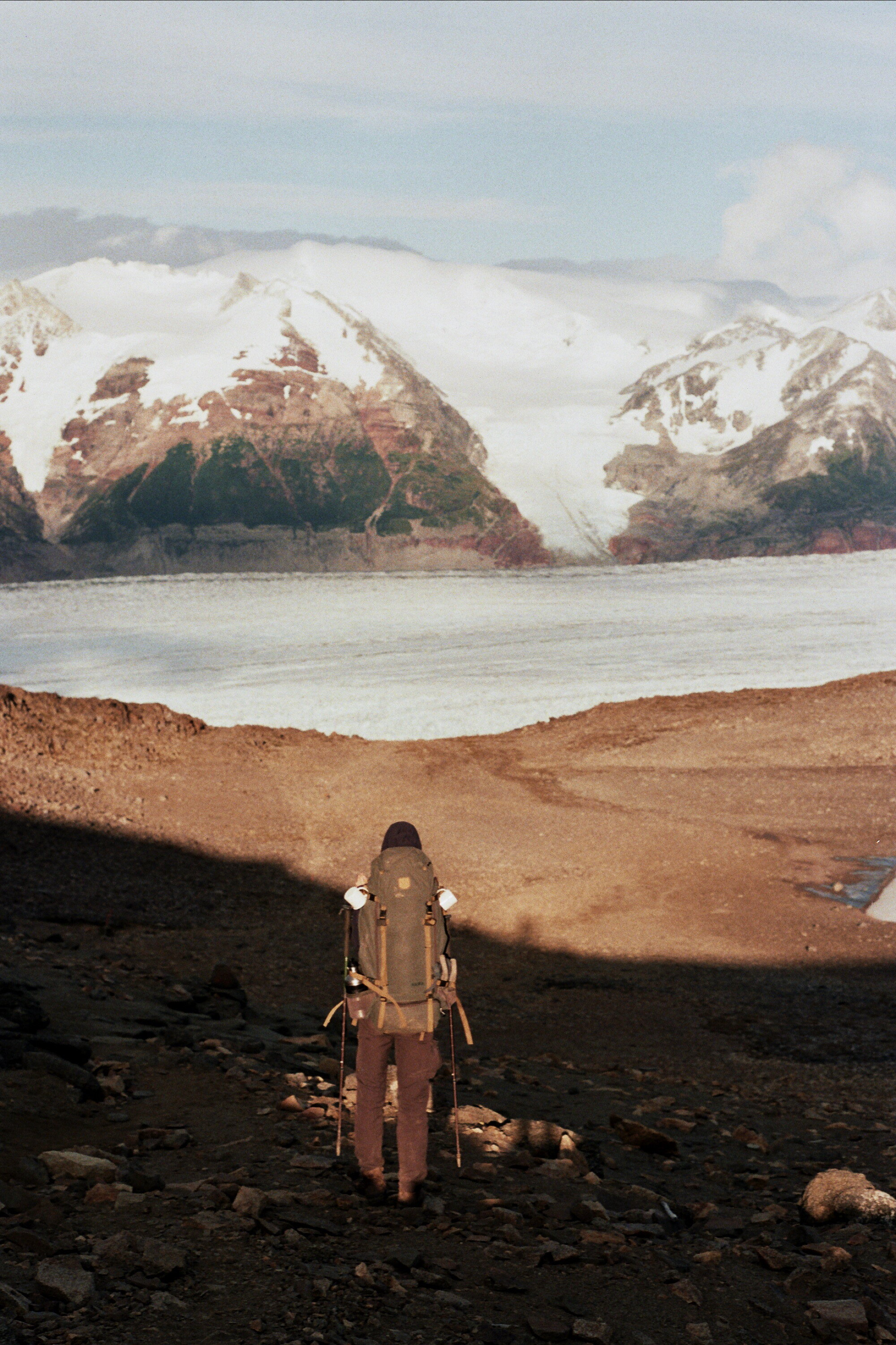
The second day proved the most demanding: a 12-hour trek covering 31 km (1,150 m ascent and 1,550 m descent). We crossed Paso del Viento and Paso Huemul, forded a river, and walked roughly one km across Glacier Tunél. That day alone, I used three rolls of film capturing Glacier Tunél, Glacier Viedma, Argentina’s largest glacier ( four times the size of Buenos Aires) and the immense Southern Ice Field, the world’s third-largest freshwater reserve after Antarctica and Greenland.
On the final day, we walked 25 km across treeless pampas in sudden heat, surrounded by dry, thorny bushes — a stark contrast to the icy wilderness of the previous days.
The constant battle with extreme weather left us exhausted, yet the most spectacular scenery was found precisely within these harsh conditions. We stared at the blue ice with runny noses, cracked skin, and blistered feet. When we weren’t walking, the cold often drove us into the tent, where we spent long hours cooking, reading and dreaming of buying land in a more hospitable mountainous area like the Alps.


National Reserve Lago Jienimeni, Patagonia National Park and Carretera Austral
We left behind the extreme south of Patagonia — the Magallanes and Chilean Antarctica regions — and arrived in Chile’s Aysén region. Here we completed a 65-km trek crossing Lago Jeinimeni National Reserve and finishing in the Chacabuco Valley, within Patagonia National Park.
The route is rarely travelled and poorly marked (especially the paths leading toward the glaciers), but the biggest challenge was undoubtedly the countless river crossings — about 30, without exaggeration. A few felt genuinely dangerous and all were freezing cold, yet the most frustrating part was constantly switching from boots to Tevas and back again.
Still, we enjoyed the milder climate, the striking colours of the lakes and rocks, the glacier views, and above all, the chance to befriend curious guanacos. By this stage, our trekking diet had evolved into surprisingly satisfying and healthy meals — often making other hikers a little envious. Breakfast: porridge made from oats, milk powder, fruit or dried fruit, and nuts; lunch: bread, wraps, or crackers with cheese or avocado and dinner: pasta with tomato sauce (or Philadelphia cheese), Parmesan, and a can of vegetables, occasionally complemented by an “encouragement cookie” or muffin.
Getting out of Patagonia Park proved unexpectedly difficult. We stood beside a gravel road from 9:30 a.m. until 4:30 p.m., when only the second car of the day finally stopped and gave us a lift to the main road, the Carretera Austral, where hitchhiking became much easier.
The Carretera Austral was built by the army during the Pinochet era, which explains why many people in Patagonia still view the former dictator favourably — the road freed them from isolation by connecting the Aysén region to the rest of the country. In Las Juntas, you can even find a large sign celebrating the general and his road.
We camped overnight in Puerto Bertrand, a charming little village, and spent the next four days hitchhiking along the dusty yet breathtaking Carretera Austral, passing turquoise lakes, waterfalls, and Valdivian rainforests, with views of Campo de Hielo Norte, Cerro Castillo, Queulat National Park, and Futaleufú.
Nahuel Huapi National Park
Back in the Argentinian Andes, the landscape felt mostly dry and yellow compared to the lush, green Chilean side; with a few exceptions, such as the Bariloche area. In Nahuel Huapi, we combined the park’s three most demanding routes — the Nahuel Huapi Traverse, Laguna Negra to Pampa Linda and Paso de las Nubes — into one continuous trek of 120 km over seven days.
Along the way, we encountered no other long-distance trekkers, only day hikers moving between the road and the Alps-like mountain huts. The section from Refugio San Martín (Laguna Jakob) to Laguna Negra was probably the toughest day of the entire journey. Due to past accidents, this route is usually attempted only with a guide, yet a few people still choose to tackle it independently.
At Refugio San Martín, a briefing about the route was scheduled for 9 a.m., but in Argentinian time that meant closer to 10 (perhaps thanks to Italian influence and the endless sipping and refilling of maté). We therefore started late, after signing the usual waiver declaring ourselves experienced mountaineers responsible for our own lives. In the end, we were the only ones who actually reached Laguna Negra; we assume the others turned back along the way.
The 9 km took the expected eight hours — an average speed of barely 1.1 km/h — revealing the severity of the terrain. We faced sections of real climbing without safety cables, crossed a steep ridge toward Pico Navidad, descended nearly 900 metres down the Cordón de los Inocentes, and then climbed another exhausting 350 metres to Refugio Italia. Added to this were navigation challenges on a poorly marked path and the burden of heavy backpacks — especially Daniel’s 25 kg load containing food for a week and all our camping equipment.
Despite the effort, we were rewarded with stunning panoramas over Cerro Catedral, Osorno Volcano, and Tronador, while condors circled above us — either performing an aerial dance or patiently waiting for us to weaken.
The following days remained demanding, but the constantly changing scenery kept our spirits high: deep blue lakes, alpine passes, jagged ridges, unusual rock formations, bamboo forests, soft mosses, prehistoric-looking trees, flower fields, dense rainforest with fuchsias, ferns and hanging lichens, waterfalls, snowfields, and glaciers. One of the greatest joys was discovering and eating sweet wild strawberries along the trail.
Day by day, we drew closer to Mount Tronador — whose name means “Thunder,” inspired by the booming sounds of falling seracs. On the final day, we reached its 2,000-metre base at Refugio Otto Meiling. To us, however, Tronador looked less thunderous and more like a giant octopus, its many glaciers stretching outward like tentacles.
This week-long trek in Nahuel Huapi was undoubtedly the most technical we completed in Patagonia, testing our physical abilities, endurance, and, perhaps most challenging of all, our food discipline. There were moments when we longed to devour an entire bag of cookies, but with limited carrying capacity, every meal had to be carefully rationed.